Showing posts with label Road trips. Show all posts

Tuesday, January 28, 2014

Busy things

I just started am email to someone to explain a lot of things that have been going on recently. I decided, this should be a blog post instead.

A doctor has been treating my mom for pressure sores (open wounds on the skin from too much pressure on a point) for several months. While he had always said surgery was an option he was trying less invasive treatments first. A couple of weeks ago my mom went to another doctor who is treating her for a fever she has had on and off for a while. The doctor said she had a bone infection and needs intravenous antibiotics every day for the next several months. However, he refused to start treatment until her pressure sores were closed. So, the other doctor proceeded with surgery. After 10 days in the hospital, my mom came home. However, the recovery will take a long time, at least two months. She is in a hospital bed with a special mattress and can do almost nothing for the next few weeks.

Classes at The Beach started back up last week. I still need to figure out what project I am going to do and what professor to work with. Right now I am in three classes that look interesting. I am blessed to have gotten the classes I want, since most of the people I know were unable to get into the classes they wanted.

Now for something fun. Before classes started, I went to Lake Arrowhead for a weekend with some people from Beach Newman. We did exciting things like played hide and seek in a cabin with all the lights off and scary music playing.


Friday, February 1, 2013

Back at Long Beach and up to San Francisco

Last week classes started back up at Long Beach. This is awesome because:
  • I got into the Nonlinear Control Systems class I wanted.
  • The class is taught by the professor who is the graduate adviser for the program I am applying for. He also gave me an A last semester.
  • My two best friends (also my only two friends) from classes at The Beach are in it. I have not had a class with them since 2011.
  • This will hopefully be the last semester I am taking classes in the grey area of being non-matriculated and working toward a masters degree.
  • I get to see the people from the Long Beach Catholic group and make some new friends.
Last weekend I was in San Francisco for the West Coast Walk for Life. Someone from the Beach Newman group is from Concord and her family offered to host anyone who was traveling north for the event. A group of seven of us drove up. Someone else did the driving, so this was the first time since 2005 I traveled to Northern California by car but did not do most or all of the driving.

I met some interesting people. One of the people we were staying with is a brony. He is a male fan of the TV show My Little Pony. I have heard they existed, but never met one before. I met someone who is a lot like Juliette from the Berkeley Newman group. As I said on the Facebook, "She has a whimsical personality, loves coloring with crayons, picks flowers to put in her friend's hair, shares [her] fashion sense, plays a harmonica, and laughs at everything." The next time I see her I should ask if she has stuffed animals of the entire cast of Finding Nemo or will be inviting 30+ people to a sleepover in her apartment.

As for the Walk for Life itself, it was good. It started at the Civic Center with some speeches. I ran into Sean who was filming things for the Salesians. Then the march went down Market street and ended at Justin Herman Plaza. Afterwards, we walked to Fisherman's Wharf and enjoyed crab sandwiches. Then we went to the National Shrine of Saint Francis of Assisi and attend a celebration of the extraordinary form of the Roman Rite, which is the proper way of saying we went to a Latin mass.

One of my favorite things about trips like this is how I get to observe and live someone else's life. We eat the same food, sleep in the same place, and are together all the time. This happened before when I visited Sidney, Amanda, and Chris (which I could not find a good post about).

I got to see what life is like for the family that hosted us. I saw what they normally do, watched the same TV shows, and meet one of their friends. After everyone got back on Saturday we all watched that day's episode of My Little Pony, Friendship is Magic. Our friend's mom was kind and made us breakfast both mornings as well as strawberry shortcake one night.

That is all great stuff, but the most exciting thing happened a few days later on Wednesday night. I talked to a girl at the Beach Newman meeting and we are going on a date next week. I have seen her at meetings for the last semester and she was on the trip to San Francisco.

Tuesday, May 8, 2012

From Baker to Las Vegas

A few weekends ago I was on the support staff for a relay race. The Challenge Cup Relay is a 120 mile relay race from Baker, CA to Las Vegas. It is for law enforcement personal.

The race is divided into 20 different stages of 5-10 miles each. At each stage, there is an EMT team to handle any medical emergencies that occur on the course. The medical radio system is used to dispatch ambulances if any of the runners go down or any of the spectators need medical treatment. Since most of the race occurs in the desert near Death Valley National Park (aka the middle of nowhere), there is very limited cell phone coverage and the only reliable way to communicate is by radio. I helped service the medical radio network.

The weather over the course can vary wildly. The weekend before the race, part of the course had snow. The weekend of the race itself was hot; it was over 100 degrees.

My assignment was ensuring the first four stages had their medical radios up and running before the runners got there. Since we issued all of the stage leaders their radios the day before, most of my field work was fixing problems, replacing fuses, and giving them speakers.

The Race
I left Vegas at 6 in the morning so I could get to the first location before the race started at 9. It was 115 miles away and I had to contend with race traffic. All of the roads in my area were one lane in each direction. The pavement was just wide enough for the lanes and the shoulders were gravel. Each of the teams was required to have a vehicle follow their runner at all times, so there were a lot of cars on the road. Driving the same way as the race required passing all these follow vehicles, while driving the other way involved avoiding the cars that were using my lane to pass. Everyone talked about how dangerous it was and how long it would take to travel any distance. For me it was a lot of fun.

This picture gives an idea of how empty the desert was. You can also see some runners and their follow vehicles.


I spent 10-15 minutes on average at each of the stages I was responsible for. After that, most of my time was sitting around listening in on the radio for any problems, essentially doing nothing. I spent a lot of time sitting at one of the repeater sites. The person in charge of the site had a camper trailer with an awning that provided some shade. I also hung out at medical base where one of our group serviced the radios on the ambulances. This was the place the ambulances took people who needed more advanced care. If a patient's condition required hospitalization, there were helicopters on hand to transport people.


One of the things I liked was seeing the immediate effects of what I did. A few hours after I replaced a fuse powering a radio at stage 2, the radio was used to call for a direct helicopter evacuation for a runner who was unconscious. There was the time I helped someone replace every part of a radio in an ambulance only to discover it still did not work. Then when I heard him test it I realized the low voltage alarm was going off. After we removed an iPhone charger from one of the power outlets it worked perfectly. Minutes later the ambulance was off to collect someone.

If I was talking directly instead of writing, I could capture all the drama and immediacy of these incidents.

We were surprised there were around 250 medical incidents for the race. Surprised because last year there were over 400. A lot of the incidents were related to the triple digit heat. For a few hours the radios were in constant use. At one point they ran out of ambulances; they had to call 911. At another time they ran out of helicopters.

Our Thermal Resonator
Out in the middle of the desert I ate some great food. Someone from our shop built a pizza oven and was making fresh pizzas. This is the oven at the repeater site I spend most of the day at. The guy wielding the pizza mover did most of the design and welding for the oven. He is an interesting character; he is a certified welder and a registered nurse.


It was some of the best pizza I have ever had. This is not just because it was the only food around; it was top tier stuff.


Here we have Tom making some pizza. In the back you can see my car sporting an MRN (Medical Radio Network) sticker, as well as the truck I have been practicing manual transmission driving with.


The Route
From home to the Riviera Hotel (where we were based out of) on Friday I drove 272.9 miles and followed the normal way into Vegas on the 15. On Saturday I took Nevada 160 to Old Spanish Trail to California 127 (Death Valley Road). I then drove up and down 127 since that was my area. By the time I got back to Vegas past midnight and after some breakfast the next morning I had driven 314.0 miles. On the way home I drove the entire race course so I could drop some keys off in Pahrump, Nevada. That took me 327.8 miles and 6 hours, 45 minutes.

During the race at some points there were dozens of cars parked on both sides of the road and the street was filled with people walking around. It was past midnight and I had to drive at walking speed to be sure I did not hit anyone. I drove by the same place later that day and there was no sign of all the commotion from a few hours ago. All that was left were some bags of trash awaiting pickup.

Thursday, March 8, 2012

A lot of work and CRP follow up

Last week I had homework due on Sunday, Tuesday, a midterm on Tuesday, and homework due on Wednesday. This week I had homework due on Sunday and a midterm on Wednesday. Next week I have work due on Sunday, Tuesday, and a midterm on Tuesday.

All of these things are keeping me busy. I wonder how I managed as an undergraduate to finish two majors, be very involved with two extra activities, and spend time with a lot of different people. Then I remember, I was a horrible student. This time at Long Beach I am making academics my number one priority.

Last week's midterm covered microcontrollers and programming in assembly. The professor decided to give everyone some extra points since the average was low. I ended up with a 104%. Yesterday's midterm was more difficult than I expected. I will find out next week how I did.

CRP
When I write summary posts of trips I often feel I fail to convey important points. That might explain why a backpacking trip from 4 months ago or a New Year's trip to Vegas have not been published yet. Before it gets too far away, I need to make this post about two weekends ago. I drove to Burlingame for the semiannual meeting of the California Republican Party. Along the way I picked up Derek.

One of the best things of conventions is hearing the interesting stories of people I know. This one happened earlier in the day before I got there. On Friday there was a lunch at the hotel. While different people gave speeches, the hotel staff served the attendees lunch. One of my friends from Berkeley (a former Editor in Chief) did not eat all of her food. She asked for a box to take out her food. She was brought a box, but the hotel staff did not give it to her immediately. She had to sign a waiver saying she would hold the hotel harmless if she became sick from improper storage and reheating of the food.

The best event of the convention was the speeches at lunch on Saturday. Rohit is the bay area chairman of Newt for President. Since the speaker was coming to the convention, Rohit had to select some people to stand on stage behind Newt to wave signs. Since I was fortunate enough to be a friend of Rohit, I got to be on stage at the same time as Newt. As an added bonus, Herman Cain also made an appearance to support Newt.

There are a few pictures of the event from the Burlingame Patch. For some reason I look less than happy, even thought I enjoyed being there.

When I planned out my driving route to Burlingame, I selected the shortest travel time possible through Friday afternoon traffic. I took the 405, to the 101, to the 85, to the 280, to the 92, to the 101 (again), to get to Burlingame. It was great. I only encountered a small amount of slowing on the 92 and the 101. The trip up was 450.7 miles.

Driving back on Sunday I made a stop in San Mateo to see Monica. I ended up taking the 82 (El Camino Real), to the 92 west, to the 101 south, to the 405 south. This route was not as carefully planned out. My plan was drive southeast and find a freeway.

The entire trip was 896.4 miles. That means my trip back (which was not as carefully planned) took 5 miles less than the drive up there.

Monday, December 5, 2011

Radios and Driving

Today in class my friend asked me what I did this weekend. He asked if I went to Arizona again. I had to say, "No, but I did make it to Nevada."

A week ago my friend from church asked if I was available on Friday and Saturday. He was conducting a radio frequency test and wanted my help. He is involved with setting up a medical radio network for an annual relay race from Baker to Las Vegas. Since I did not have anything planned, I went on the trip.

I woke up around 3:15 on Friday morning and drove to my friend's house. He then drove us to Baker. If you are not familiar with the city of Baker, it is know for two things: having the world's tallest thermometer and being one of the the major stops on the 15 on the drive to Las Vegas.

Our first task was to put up three radio transmitter towers. These were placed at three different sites as far as 100 miles away from Baker. Next each of the transmitters had a setup to transmit a test signal every minute on a specific frequency. Setting those up and getting them up and running took all day.

While the area is a desert, it was cold. It dropped below freezing in some places during the night. On Saturday there was a lot of wind. I was outside for just two hours in the morning and the wind was unrelenting. I had a jacket, hat, and gloves but it was not enough. I was cold.

During the trip many problems came up. They were all the result of working on things until the last minute and poor planning. My friend was frustrated these issues appeared, but he also knew what steps to take to fix them for next time. Everything required was accomplished, but there was a lot of work, calibration, fixing, and figuring things out in the field. I hope I can help fix or reduce many of these problems.

We set up three cars with radio receivers which then drove the race course at 25 mph. Every minute the strength of each of the three radio transmitters was recorded along with the position of the vehicle. When the data are analyzed, we will be able to see if there are any areas on the course with poor radio coverage.

I liked seeing how radio transmitters are set up in the field and tested. The ideas involved were simple, but watching them come together and work was great. When issues came up everyone had to improvise, so I saw a lot of problems solved.

Learning to Drive
The most exciting thing for me was learning how to drive a vehicle with a manual transmission. For those of you not in the know, operating a manual transmission can be a lot of fun. However, there is a big learning curve. Making a mistake will cause the car will start moving when you want it to stay still or stay still when you want it to move. Hopefully when these thing happen you will not hit anything.

In cars with a manual transmission/stick shift/standard transmission there is a third pedal for the clutch and a stick on the floor to select a gear. The driver needs to select the best gear based upon the amount of torque and speed the car needs. When a car is just starting to move, it needs a lot of torque. However, after the car is moving, it needs less torque and more speed. In the truck I drove, the gears are labeled 1, 2, 3, 4, 5, and Reverse. There is also Neutral, which is when none of them are selected. You start the car in 1 and after the car is moving you can hear the engine turn faster and faster. Looking at the tachometer and listening to the engine, you can tell when the car needs to be shifted into a higher gear. Putting the car into a higher gear is the easy part.

My biggest problem was starting the car or getting it moving after a complete stop at a stop sign, stop light, or after some pedestrians ran right in front of me. You have to release the clutch pedal and apply gas at the right time. If you release the pedal too fast or do not apply the right amount of gas, the engine will stall and you will have to turn the key to start it up again. While this is happening, the car is not braked so you could be rolling backwards if you are on an incline. This weekend I only stalled the engine twice in the middle of traffic. When I tried to start the car on a hill it took me a few tries and the cab was filled with the smell of ground metal as the gears smashed into each other.

Breaking and slowing down are also different. To brake, the clutch pedal has to be pushed in before the brake is applied and as long as the brake is in use. If the brake is pressed while the clutch is still engaged, the engine will stall. If there is significant slowing, you will need to downshift to a lower gear for when you start applying the gas again.

Like any skill, driving a manual transmission is something that gets better after more practice. I drove over 200 miles this weekend, but most of that was high speed highway driving. I still need to practice a lot of stop and go driving.

Sunday, December 4, 2011

Victory on the road against ASU

This weekend and last weekend I went on trips. Both of them were planned a few days ahead of time, involved driving to another state, and were fun. They were so interesting I broke them into two different posts.

This one is about last weekend. It was Thanksgiving weekend and I went to Arizona to watch the Bears play their last regular season football game.

ASU band opening A
Earlier in the week Sidney posed on Facebook saying he was interested in going to the game and looking for people who wanted to join him. I was interested, so I replied. Sidney and I have been on many road trips together and they always result in fun.

On Friday morning I left my house and picked up Sidney. When we were on the 60 traffic slowed to a crawl. Sidney pulled out his phone and discovered there was a six car pileup in front of us on the freeway. He then figured out an alternate route so I could exit the freeway and take country roads instead. I followed his directions and after ten minutes of driving I was speeding along the 10. His phone projected our new route saved us one hour.

We were going to stop near Palm Springs and check one of the outlets for Cal attire, but there were a lot of people. Apparently even at noon in the middle of nowhere on black Friday there are a ridiculous number of people shopping. Cars were parked on every street, people were selling spaces on their lawn, and golf carts were ferrying people from their cars to stores.

We got to Tempe about an hour before kickoff. There were plenty of spaces in our lot across the street from the stadium. After buying tickets, we walked around the outside of the stadium. It was on the edge of the ASU campus and downtown Tempe. We saw dorms, stores, restaurants, city buildings, a statue of Charles Trumbull Hayden, and some natural landscaping around the stadium.

We entered the stadium and took our seats. As can be seen from the pictures, we were at the top of the stands in the corner of the stadium. Sidney was his usual game day self, which is loud. We wanted to make sure the ASU fans knew the Cal contingent was spirited despite our small numbers. When the Sun Devils made their appearance, fireworks were fired from the field.

ASU opening fireworks
The game was a lot of back and forth. Each team kept scoring. With 2:59 left in the first half, California kicked a field goal for a 27-14 lead. After the kickoff, I told Sidney it would be great if Cal could hold ASU back so they would not score in the final minutes of the half. Sidney told me he would be happy if we had the lead heading into halftime.

With 1:02 left on the clock ASU scored a touchdown. After the extra point, ASU kicked the ball to Cal. The return team grabbed the ball and starting running. However, the person with the ball was hit and fumbled, with ASU recovering it deep in Cal territory. After a few plays ASU got a touchdown.

My earlier hope of stopping ASU was too optimistic. Sidney's goal of Cal being in the lead at the half was more reasonable, but still too much of a reach.

During halftime, Sidney and I sat with Michael, who we know from Newman activities. He had a good spot near the 50 yard line and the people sitting near him left during the first half.

The second half was more back and forth. There were penalties, great plays, and even a call that needed a video review. In the end the Bears prevailed 47-38 to finish the season 7-5. Next up will be a bowl game. If I get my hands on a picture of Michael, Sidney, and myself I will post it. (Posted on 12/10)

After victory against ASU

The field after the game.

Field at end of Cal victory
After the game all of us went to Chris's apartment. I know this Chris from more church related activities (at this point the game could be considered a Newman reunion) and learned about how he likes living in Arizona. The next morning Sidney and I saw Chris again and enjoyed a small outdoor food fair.

This was my second trip to another state to watch Cal play football. Like my first one to Oregon in 2007, I am glad to say it was a fun game to watch and the Bears won.

The trip was 788.7 miles and I drove the whole way. I went from my house to Sidney's parents' house to the 91, the 60, and then the 10. On the way back we stayed on the 60 until the 57 and took that to the 91.

Saturday, August 27, 2011

A trip to Pinnacles

A few weeks ago I went to Pinnacles National Monument with Larry and Peter. It was fun; we hiked and car camped.

Peter in front of lake
The idea for this trip started when Larry got back from Vietnam. On a Wednesday we went to the OC Fair with Peter. Larry said he wanted to go on a nature trip before he left for Arizona in a couple of weeks. After thinking of a few places, I mentioned some people I knew had been to Pinnacles National Monument which is near Salinas.

On Thursday of next week our trip started. We left around 9 at night. As always, I did the driving. It was around 3 in the morning when we pulled up to our campsite. Luckily we were the only ones in that area so we did not disturb anyone. It was good Peter and I had practiced pitching our big 4 person tent a few days earlier. Aside from being dark, it was 47 degrees out.

Around 7 in the morning we awoke. Larry cooked bacon and eggs on a stove, but the bacon did not work out well. It had a lot of fat but did not produce all the grease we wanted for cooking the eggs.

We started on the trail at 9. Both Larry and I were concerned about being out of shape. Larry did very little physical activity in Vietnam, while I was long out of my habit of bike riding or even walking. Looking the the maps, Larry had planned a dozen mile loop around the park. It would take us through both caves in the park and most of the noteworthy trails.

We started at the Bear Gulch day use area, which was a short drive from our campsite. We went 1.2 miles through the Moses Spring trail to end of the Bear Gulch Cave trail. The cave was not very exciting. It might have been better if it was not partially closed for bats.

We went for 1.9 miles on the Rim trail and High Peaks trail until we reached the start of the Juniper Canyon trail. We had to go uphill but from the top we could see the clouds settling over a valley in the distance.

Larry on a bench
After the entire 1.8 miles of the Juniper Canyon trail we reached the west entrance of the park, the Chaparral Parking Area. It was 90 degrees that day and we had hiked 4.9 miles, so we used the opportunity to fill up our water. Throughout the monument I saw a few California Condors flying around.

From there we followed the Balconies trail to the Balconies Cave trail. Peter was always leading the way.

Peter walking into canyon, called a cave
After our trip to the Lava River Cave in Arizona, we were looking forward to the caves. We brought extra clothing, extra light sources, and even purchased headlamps. However, the caves were a big disappointment. They were more like very short narrow canyons where some big rocks had fallen in and blocked out some light from above. The picture below was taken in the best part of the caves. If it would have been like this a lot longer it would have been a real cave. I should have looked up what a talus cave was when I saw it on the website.

Me in cave with headlamp on
After eating in the cave, we took the Old Pinnacles trail for 2.3 miles. This was nice because it was flat. Then we had a choice; we could take the Bear Gulch Trail back for a flat 1.6 miles back to my car, or take the High Peaks trail to the Condor Gulch trail for 3.7 miles. Which one do you think we chose?

Watching Larry and Peter hike uphill
The High Peaks trail also went up 1,300 feet. I almost died going up this hill. I was huffing and puffing like the Big Bad Wolf. Peter and Larry were doing OK, but I had to stop and rest a lot. At one point I laid down on the trail. However, I was worried the vultures I had seen earlier would start circling around me. I kept telling myself "If I can handle the Grand Canyon, I can handle this." When we got to the top we had this view.

View of Pinnacles from hill
We took the Condor Gulch trail down and back to my car. The hiking totaled 11.7 miles with a lot of ups and downs.

When we got back to our campsite we sat in the shade and waited for the sun to go down. For dinner we cooked pasta with a lot of spam and Vienna sausage.

Spam and pasta dinner
Since the fire warning was at its highest possible level, they did not allow campfires. Using the showers at the campsite took a lot of time. Only one of the showers was working and it worked on quarters, with a four minute waiting time between uses.

Car parked at campsite

The Drive
From Peter's house we took the 22 to the 5. We exited the 5 at Coalinga, then took the 198 to the 25 to the 146. The 198 and 25 were a lot of fun to drive at night. These winding hilly roads had turns that had to be taken at 25 or 30 MPH. There were very few other cars. My biggest concern was all the wildlife. There were rabbits all over; I ran over two or three of them driving. The entire trip took 636.7 miles. As with my earlier experiences, driving to the national park or monument is a bunch of fun.

We got back around 5 on Saturday afternoon. We had something important scheduled to do on Sunday, we went to Disneyland. The interesting things we did included going on the new Star Tours, which was not as good as I had hopped (I yelled at Jar Jar Binks). We also did the Toy Story Mania! shooting ride in California Adventure. You sit in a car that is taken to different places where you shoot at targets on 3D screens. Also seen was the show The World of Color in California Adventure, which you should get a Fastpass for early in the day to get into a viewing area. Imagine the Bellagio fountain show with lights and a lot of projected Disney characters and you get the idea. A couple hundred pictures of the day were posted online.

The Group at Disneyland

Overall the Pinnacles trip was good, but the place itself was not as good as our other National Park adventures.

Tuesday, June 14, 2011

Motor City, a Wedding, and Second Cousins

Two weekends ago I was in Detroit for a family wedding. My second cousin got married. Before I get to the interesting and fun, I will explain some family background and the genealogical term second cousin.

On my mom's side of the family, I do not have many close relatives. My mom is an only child. However, my mom is close to her cousins. When they were growing up they all lived near each other and would assemble at their grandmother's house every Sunday. Since my mom's cousins had a lot of children, I have a lot of second cousins.

Now a word on second cousins. Regular cousins (or first cousins) are the children of your parent's brothers or sisters. The closest common ancestor first cousins share are two of their grandparents. Second cousins are people whose closest common ancestor is two of their great grandparents. On my mom's side I am connected to my second cousins because we have the same great grandmother and great grandfather.

How well I know these people varies. In the mid 90s there were a few big family reunions. At some point I met all of my second cousins (cousins from now on). However, most of my cousins were a bunch of names I heard but did not know. Most of this is geography. My cousins currently live in Michigan, Ohio, Pennsylvania, New York, and Georgia. When I lived in Ohio it was easier to see them occasionally, but that was 14 years ago.

In spite of the intervening time zones, I know a few of them to some degree. I know the ones who live 10 minutes from my grandma because I see them almost every time I visit her. I also know the ones who live in Michigan because my family did things with them. We saw them when we went to Detroit, went to sporting events with them, and even went to Montreal with them. The bride is from that family so I know a few things about her as well as her brother and sister.

Since I had not seen some of my cousins in 16 years, I had no idea who was who. My mom was clueless as well. She could tell me the names of Uncle Mike's or Uncle Joe's children, but she could not match the names with faces. I spent a long time talking to who I thought was Gabby, but I learned the next day it was actually Tori. It was only after I asked my aunt for help that I got everyone's name correct.

I learned my cousins are up to varied things such as:
  • Training to be a mad scientist. He is pursuing a degree in chemistry and German.

  • Preparing to be a priest. He is a few years into the seminary.

  • Obsessed with doing the creep from this Saturday Night Live video. I thought she was dancing like a t-rex until she explained it.

  • Watching the TV show Burn Notice. It is her favorite show and she watches it with her husband.

  • Looking for a major related to art and being involved with Newman activities at her college.

  • Living every little girl's dream. She has a horse named Patriot.

  • Frequenting the local bars and being friends with the sample girls for Dewar's Scotch.
I did not have a chance to learn something interesting about all of the 11 of my cousins who were there. All I learned about Emily is she is blond.

I should throw in a picture, so here is Annie and me.

Annie and me

Detroit
I did a lot of driving in the Motor City. Before leaving home, I decided to memorize the locations of the airport, my hotel, the church, the reception, some local places to eat, and how to drive between all of them. The first day I was there I drove 208 miles. I drove on such freeways as the 94, the 75, the 696, the 275, and even the 96.

Here is a wedding program, favors, and some cereal that is made in Detroit.

Cereal and wedding program
I would have put my own name tag in this picture, but it was thrown away. Sometime between talking to my cousin Gabby and the band finishing Neil Diamond's "Sweet Caroline" it disappeared from my table.

Being in Detroit reminded me that a lot of places have a lot of differences from Orange County. There are places where every block is not tightly packed with as many houses and stores as possible. The houses in Michigan had big yards and the cities were spread out. In a similar vein, are you familiar with pop? If you want a soft drink in Michigan everyone calls it pop, not soda or coke. If you want to learn more this map shows the regional distribution of what terms people use to describe soft drinks.

On one last Detroit centered comment, at the wedding they played Journey's "Don't Stop Believin'." I learned there is no South Detroit. It is either Windsor, Canada or someplace downtown.

Tuesday, May 31, 2011

Lost in the Woods

This is the third and final post in my series on my trip to Arizona. The earlier two parts covered the Lava River Cave and Slide Rock, as well as Horseshoe Bend, Glen Canyon, and Page, Arizona. Chronologically this occurred between those two posts. However, I decided to save the best adventure for the end.

On the same day we went to the Lava River Cave and Slide Rock, we went to the West Fork of Oak Creek Canyon. It was a few miles away from Slide Rock and just outside of Flagstaff. The park is managed by the Arizona state park service and the US Forest Service. I drove into the parking lot and paid my entrance fee just after 4 in the afternoon.

The trail was 3.0 miles one way with a 5300 foot elevation at the trailhead. The way back was backtracking the same trail. It was flat, with the elevation change being 150 feet. It was around a mile from the parking area to the trailhead.

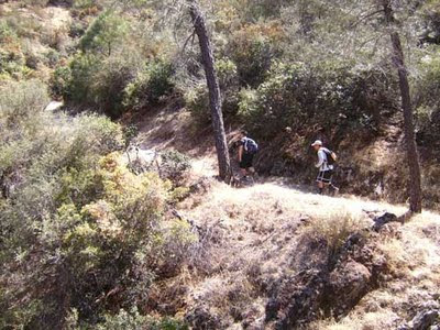
The biggest feature of the hike was the creek itself. Going into the woods, the trail crossed the creek over a dozen times. It was normally only a few inches deep, but there were stones at all of the crossings. Here Larry is acting like Captain America and balancing on a loose branch.

Larry on log crossing stream
On one of our first crossings I fell into the stream. I got a little wet, scratched up one leg, and got a big bump on my other leg. An area over two inches in diameter swelled up instantly. However, it was not too bad so I kept walking.

As before, Larry wanted lots of pictures. I tagged along and got in a few of the frames.

Larry and me at edge of Oak Creek
We kept hiking. Peter did most of the leading, while I was at the end most of the time.

Group hiking trail into Oak Creek
Aside from the creek, there were lots of larger rocks. Every rock worth climbing on or getting a picture of was climbed or photographed. The most iconic rock had a flat face and was next to the trail.

Larry on big rock
I watched Larry climb it and knew I could get to the top as well. However, what concerned me was getting down. It is a bad idea to go up without having a plan to get down. After some thinking, I decided I wanted to get to the top so I pushed all my concerns aside and started climbing.

Larry, Peter, and Me on top of the big rock
After both of us were on top, Peter decided he had to get to the top of his rock.

There were a lot of creek crossings. Since they all had stepping stones and were clearly visible this was not a problem.

Peter at Oak Creek crossing
We knew we reached the end because the creek went off and there was no trail to follow it.

End of trail for Oak Creek Canyon
This is one of the many pictures at the end of the creek. It seems I did not pack my smile.

Group at end of Oak Creek trail

The Trip Back
While Larry, Peter, and I were used to hiking (the three of us have hiked the Grand Canyon, Bryce Canyon, and Zion National Park), Eric and Andy were not. Andy was not in shape.

As we started the way back the sun rapidly set and it was getting dark. We were making good time. Then we lost the trail. While there was only one main trail, it was a heavily visited area and people had worn out a lot of smaller paths to the stream at different points and up to higher vantage points. After some scouting and stream crossings, we found the main trail again and were back on track.

Earlier in the day it was 80+ degrees so none of us were prepared for the temperature drop when it got dark. At one of the creek crossings Andy slipped on a rock and got wet. We dried him off as best we could, which was very little. We continued on and the trail took us to the creek as it often did. However, there was no crossing and we could not see a path on the other side. We deduced we had made a wrong turn earlier so we turned around and went back. At this point the sun had set and all of us pulled out flashlights. Luckily, we all had flashlights packed from the Lava River Cave earlier that day.

After a lot of walking there was more uncertainty. We started to think we had taken a wrong turn again. We took some tree branches and started leaving markers on the trail. Then the trail took us to the creek again, but we did not see a crossing. We surveyed the other side with flashlights but did not see a trail. We turned around.

While it was not very cold out yet, the temperature was going down and we did not have jackets or even long pants. I knew I could keep going for a while but Andy did not look well. He was winded and with his feet wet he was not handling the cold well. We ran into one of our markers so we knew we were going in a circle.

While we did not know if we were going the correct direction, we kept going. I started to think about what to do if we had to spend the night somewhere outside. There were no places that looked like good shelter. At one point the trail split. We decided to let Andy stay at the fork while Peter and I scouted one way and Larry and Eric checked the other. Peter and I found the trail crossed the stream and had a visible crossing. Larry and Eric were gone a long time. When they came back we debated about which way to go. I remembered going against the flow of the creek for the entire second half of the hike on the way in, but I did not remember if we were going with or against the creek for the first half of the hike. There was also the possibility there was a second creek that intersected the main one. We decided to take the way Larry and Eric came. As we walked Andy looked bad. There was concern Andy was going to faint and we stopped and made him drink Gatorade a few times. We walked for a while and came to a crossing that looked familiar. However, we still could not agree if we were going out of the forest or further into it. After we crossed the creek, there was more hiking until the trail forked with one side following the creek and the other going further into the woods. The sun had set a couple of hours earlier and all of the rocks and trees looked the same.

Larry remembered this fork from the hike up because I had suggested we follow the stream while Peter suggested we go further into the woods. Larry also remembered we took Peter's suggestion. However, Larry and Peter decided to scout one of the trails before we made a decision. I sat with Eric and an exhausted Andy while they went forward. They walked a long way and almost gave up, but one of them said to keep going for a few more feet. They came to a rock. It was the big rock with a smooth face that Larry, Peter, and I had climbed on the hike up.

They knew we were going the wrong way, but they were excited to find a sure point of reference. When they came back, they told us and we started backtracking. My flashlight started to die on me. Luckily, I had an extra light in my bag from the hike in the lava river cave earlier that day. The very first crossing we came to Andy slipped and face-planted into the water. He was soaked. This made us go as fast as we thought Andy could handle, as if the dropping temperature and desire for food was not enough to keep us going.

We hurried and made good time. It seemed the fall had given Andy a second wind. We found a marker we had left earlier so we knew we were on the right path. Larry kept saying he thought the next creek crossing was the one where I fell. After an hour we finally recognized the starting stage of our hike. We kept going and the trail became a sidewalk that took us to the parking lot.

At the end I was never happier to see my car. We pulled out some dry clothes for Andy and I started the heater. Then I went and looked at the entrance to the parking lot. The gate had been closed and locked shut. It was the only way for a car to get in or out. The signs said the park closed at dusk. Even though my car was parked right next to the gate they decided to lock us in. Larry and Peter tried to make phone calls, but as soon as they were connected and started talking to a person it cut out. Next they went to a nearby house and knocked on the door. There was no answer. They tried the phones again and eventually got through to the county sheriff. Peter told them where we were and they told us to wait. Almost an hour later the sheriff came and unlocked the gate so we could leave. As I drove out the time was just past midnight. We had been in the park for nearly 8 hours.

Since it was dark for most of the hike back, we did not take any pictures. However, this one says it all. The trees and rocks around us looked the same, it was dark, we had no idea where we were, and everything was a blur. Larry's reaction speaks for our collective mood.

Blurred picture of Larry in dark
Eric's album Beware the ~Call of the Canyon~ ! has more pictures. His album description summarizes the trip, "Did you know that there is a Blair Witch 3? How do I know? We lived it!"

This brings new meaning to the phrase Lost in the Woods.

Monday, May 30, 2011

Horseshoe Bend, Glen Canyon, and Page

Now for part II of my Arizona trip; part I was yesterday.

Horseshoe Bend
We piled in the car Saturday morning and I drove 150 miles north. Our first stop was Horseshoe Bend. It is a place where the Colorado River rounds a bend to make a 270 degree change in direction. It was a 3/4 mile walk from the parking area to the viewing area.

Trail to Horseshoe Bend
The scenery was scenic; check out the clouds in these pictures. Below we have another picture of Peter on one of his many rocks.

Peter on the rock at Horseshoe Bend
As the signs pointed out, there were no railings and it was a 1,000 foot drop from the edge to the river below.

Larry at Horseshoe Bend
This shows the top of the canyon the Colorado carved. I am sitting on a rock.

Canyon top of Horseshoe Bend
In case you did not get a good look at the earlier shot, here is another picture of Horseshoe Bend. I kept thinking how this was the same river I crossed when I went to the Grand Canyon last summer.

Horseshoe Bend
More pictures are available at Eric's Horseshoes Around The Bend album. Next we drove over a bridge and saw the Glen Canyon Dam. This is a view of the bridge from the visitors' center.

Glen Canyon Bridge
Both the Horseshoe Bend and Glen Canyon were right next to the city of Page, Arizona.

Me at Page, Arizona sign
Eric's Dam You Glen Canyon album covers the Glen Canyon Visitors' Center and the drive back.

Driving Summary
The entire Arizona trip was 1480.2 miles. My car got 28.73 miles per gallon. That is good considering my car is ten years old and had almost 100,000 miles on it. Most of the trip had people sleeping in the back seat while I did all the driving.

Larry and Andy asleep in car
To get to Chandler I took the 55 North to the 91 East to the 60 East to the 10 East. On the 10 I had some fun driving. There was construction and I was making turns following cones; it felt like a video game. After 309 miles on the 10, I took Arizona 202 East to Larry's house in Chandler. Then to get to Flagstaff, I took Arizona 101 North, to the 17 North which became US 89.

To get to Page, Arizona, I went north on US 89 from its starting point in Flagstaff. I did a lot of driving on the 89 on my last trip to Utah, so it was exciting to be driving on the 89 again. There were great views of desert landscape and passing other vehicles was fun.

Going back to Chandler, I took the 89 South to the 40 West to the 17 South which became the 60 East before I took Arizona 101 South. I drove 270 of the 290 miles of the 17 freeway. Part of the 60 I drove on is called Superstition Freeway. I think it takes its name from the Superstition Mountains which it passes through to the east.

Come back tomorrow for the third and final post on my trip to Arizona. When the events I will describe were happening Larry said "I can't wait to read Chris's blog post about this."

Did you notice the new background picture on my blog? It was taken by Eric on the 89 South on the drive from Page to Chandler.

Sunday, May 29, 2011

Climbing on Rocks & Into Caves

Last month I went on an epic trip to Arizona. I went there to visit Larry, who was taking classes at ASU. The trip started when I drove Peter, Eric, and Andy to where Larry was staying in Chandler, Arizona. I left Orange County around 10 on a Thursday night.

Lava River Cave
On Friday morning we woke up and drove to Flagstaff, which was 150 miles away. A few miles outside of Flagstaff I turned onto a dirt road. After a few miles of a bumpy drive including potholes, rocks in the road, and having to drive off the road so I would not get stuck, we arrived at the Lava River Cave.

Dirt road
There were some rocks around a hole in the ground. We descended into the hole and started our trip down the 3/4 mile long cave. At first it was difficult. I had to climb down rocks that were sometimes covered with ice. However, I quickly reached the floor of the cave and the rocks leveled out.

Entrance to lava river cave
The cave was cold. It averaged 35-40 degrees, even though it was 80+ degrees above ground. We had hats and gloves to keep us warm. After a short distance it was very dark in the cave. Nothing could be seen. This is what it looked like without our flashlights.


The cave was a very scary place. There were random ice patches on the rocks and small puddles of water hidden on the floor. There were sharp rocks all over and many outcroppings hanging from the ceiling. It was a place darker and lonelier than the most deserted night. Just ask Eric.

Eric scared
The cave varied in height. Most of the time I could walk upright without hitting anything. At times the cave was over 30 feet high and even wider.

Group in cavern
As we walked along, Larry said we should be sure to take the left path when the cave branched. He had researched the cave beforehand and knew the right route was only 2 or 3 feet high at one point. Since Peter was in the lead, we put him in charge of leading us down the left path. However, Peter missed the fork in the cave and lead us down the wrong side. We had to crawl to get through the opening. For most of the cave the floor looked like a river of lava that had hardened in the middle of flowing. (Actually, that is exactly what the floor was.) There were sharp points all over the floor. My hands were not happy.

Low ceiling as we crawl
Eventually we got to the end of the cave. After some pictures and spending some time in complete darkness, we started back out to the entrance. This time we were careful to take the other side which was taller.

Group at end of lava river cave
Climbing back to the entrance I slipped on one of the icy rocks. I instantly reached for the nearest thing and cut my hand grabbing a jagged rock. There was only a little blood, but it was enough to get on my pants. You can also check out Eric's Cave Time, Lava River that is...album.

Slide Rock
After going to a Chinese restaurant in Flagstaff, I drove to Slide Rock. It is a stream that flows through a rock filled area. There were a lot of people there in the water. Aside from the opportunity to get into the water, the place was unremarkable. Here we have Larry and me sitting on a ledge. Larry is eating some ice cream, while I am using a hat and towel to keep the sun off of me.

Larry and me at Slide Rock
At Slide Rock a theme was started. Peter was sitting on a rock and we started calling it Bui's rock. After that, every big rock that anyone could climb on top of was called Bui's rock.

Creek at Slide Rock
Another theme was Larry had to jump on every big rock and demand pictures be taken. Eric's album FINALLY...Slide Rock has come back? only has half of the pictures we took on the rock above. My camera was borrowed and a bunch more were taken that did not make it online. While many of the pictures were great, after you have seen a few you get the idea.

Check back tomorrow for the second part of my Arizona trip. I visited the second largest dam on the Colorado River and a city named for me.

Thursday, March 24, 2011

A Weekend in Sacramento

This weekend I was in Sacramento. I was there to attend the California Republican Party Convention. Instead of giving a detailed treatment of everything I did and what was discussed, I will describe a few moments from the weekend.

Friday
I was driving up the 101 when all three lanes of traffic came to a stop. There was a hit and run accident where a motorcyclist was killed. It took me an hour and a half to travel 5 or 10 miles.

The 101 was green and I could see snow on the tops of some of the hills. I was taking the coastal route to pick up Derek near Santa Barbara.

I stopped in a town so small the gas station did not even have a restroom. I expected better out of a town that was important enough to have its name listed on the mileage chart with Salinas and San Francisco.

Saturday
I ordered a pancake and a scrambled egg at Jim-Denny's. I went there with Derek for breakfast because he remembered seeing the place on the Travel Channel's Man v. Food. After he described their pancake, known as the hubcap, I knew I had to eat there. The link has a video that shows what the pancake is like. Unfortunately, I was not able to finish the pancake. It was dense and very thick.

I went to mass at the Cathedral of the Blessed Sacrament. It was only a block away from the hotel. While he was not the celebrant, the Bishop of Sacramento, the most Rev. Jaime Soto, is a graduate of my alma mater, Mater Dei. The church looked like an old cathedral inside and outside.

While I did not see this, it was described to me as a scene out of a movie. Rohit was standing and talking with a few people at the convention. Someone approached the group and was eventually introduced to everyone. He then handed Rohit an envelope and said "Have a good convention" before walking away. Rohit was served with court papers.

I heard Mississippi Governor Haley Barbour speak at dinner. He gave a great speech.

That evening I was at a hospitality suite and had to divide my time between a bottle of pale ale in one hand and a flute of champaign in the other. After I finished one of them I enjoyed a dessert courtesy of Tom Del Beccaro who was running for party chairman.

There was one more event I was not present at. At one of the suites that night a gentleman attending the convention had a heart attack and died.

Sunday
Attended a prayer breakfast where Star Parker spoke. She gave a great speech. Parker also has an uplifting story.

In the parking structure I was at the elevator on the second floor. There was a sign that said "Take the elevator to the fitness center on the first floor." There was a stairway right next to the elevator. Apparently one should only get fit at the fitness center and not on the way to it.

I left Sacramento at 1 PM. I planned on taking the 5 and returning the same way I got there. However, the signage was confusing and I ended up crossing the same river twice and following construction detours before I got onto a freeway. After a few miles I learned I was not on the 5 but the 80 west. I figured turning around would take more time than following the 80 as a alternate route. As I drove through the east bay I thought it would be wonderful if I had enough time to call up and visit some of the people I knew who lived only a few minutes away from where I was driving. Even without any extra stops it took me 10 hours to get home.

I stopped at McDonald's to eat a late lunch. I enjoyed an Angus Chipotle BBQ Bacon Burger. While I selected it because it looked like the best item on the menu, I was reassured I made the correct choice when I noticed it also had the most calories of any burger on the menu.

I have driven between Northern and Southern California more times than I can count. With the rain on Sunday the conditions were the worst I have ever seen them. It was raining for more than half the time.

Now the exact route. To get to Sacramento I took the 405 north to the 101 north to the 152 east to the 5 north. This took 536.2 miles. On the way back I took the 80 west to the 680 (which I drove in its entirety) to the 101 south to the 405 south. The entire trip was 1062.3 miles. The way I accidentally took to get back was shorter in distance than the route I planned taking north. However, if I had taken the 680/80 traveling to Sacramento on Friday I would have run into more traffic.

Sometimes people talk about feeling a retreat high. It is a feeling of happiness and a determination to live better after going on a retreat. It could be said after the convention I am on a Republican high. I want to dismantle unnecessary government bureaucracies and lower taxes.

Wednesday, January 5, 2011

Bryce Canyon Driving and Las Vegas Eating

Raining, snowing, raining, snowing, raining, snowing, raining, and more raining. That is what actually happened to me on my last trip. The driving was some of the most scenic, dangerous, and fun I have ever done.

The driving and weather conditions
This is how I got to Bryce Canyon. It was raining as I started my driving. From Larry's house I took the 22 to the 57 to the 60 east to the 15 north. The rain and fog were all around and it was difficult to see the other cars. As I drove into Nevada the rain continued and by the time I made it into Arizona it turned into freezing rain. When I made it into Utah the freezing rain became snow and lightened up. I exited at Ceder City to take Utah 14. It was a mountain road through a forest and a true winter wonderland. It was a winding road that traced shapes I have never seen on street signs before.

After 40 miles of that fun I took US 89 north to Utah 12. As I drove the scenic route at night I could see where the road went under rock arches. I turned off at the 63 and went south until I found Ruby's Inn where we stayed.

Ruby's Inn was more than a hotel; it had a restaurant, general store, liquor store, equipment rentals, laundromat, barber shop, photo place, and tour reservation center. In the general store, they had a lot of gifts. One of them was a glass with an expression on it. What would be your first thoughts on reading it?
Eat, drink, and be merry, for tomorrow we may be in Utah
I thought it implied being merry did not happen very often in Utah. Before I could voice this sentiment, a person who overheard me reading the glass chimed in "I was born in California and then rudely brought to Utah when I was a few years old, and I emphasize rudely brought."

Then I went on a trip to Zion which I covered in an earlier post.

The Departure
The morning we left Bryce Canyon it was snowing. I planned on taking the same route back I had taken to get there. As I turned onto the 14 it was not ploughed as well as the 89. However, the gates were open so I determined the road was open. As I drove the conditions became progressively worse. I could see where a tree had fallen into the road and had been cut by a chainsaw to clear the road. There were fresh tire tracks in the road, so I was not worried.

About a quarter of the way through this 40 mile road the path narrowed. There was only one ploughed lane. Then I came across a car that was going the other way. Since there was over two feet of snow on the ground and only one lane was ploughed we had a problem. We got out of our cars and conferenced with the drivers of the two trucks that were following me. I learned a service vehicle was stuck on the road ahead and the car in front of me had turned around because the road was impassable. The other people suggested I back my car out until the road became wide enough to turn my car around. A helpful local person I talked to said this was one of the worst storms he had seen in the last 30 years of living there.

I started backing my car out, but it was difficult for me to follow the road. I asked Peter to get out and walk the route so I could follow his black jacket instead of white tracks in white snow. After half a mile of this and almost running over Peter a few times I decided to turn the car around. I slammed the back of the car as far as I could into one side of the road. I did not get very far because the front tires got caught in the snow. I cleared the snow but the tires were still spinning. The other driver, Larry, and Peter pushed the car as I slammed on the gas. After some maneuvering and coordinated pushing, the car was successfully turned around.

After backing my car up for over half a mile I had a new appreciation for driving forward in the normal way.

A Detour to a Detour
Since Utah 14 was closed I needed to find an alternate route to get to the 15. After talking to the kind person who helped me turn my car around and a friendly gas station employee, I learned the snow became rain only a short distance to the south. I headed south and planned on taking Utah 9 through Zion National Park. I had driven to Zion a few days earlier so my entry fee had already been paid.

The snow turned into rain as I was traveling south on the 89. I turned on the radio for Zion travel information. The radio said part of Utah 9 was washed out in the park due to heavy rain and the road would be impassable for several days. I made a detour on top of the detour. I drove south and in Kanab took 89 A (an alternate 89) to Arizona where I hopped on Arizona 389. This undivided highway (or single carriageway) had wonderful landscapes. There was nothing except desert and mountains in the distance.

Arizona 389 became Utah 59 and that dumped me onto Utah 9. I followed it to the 15 and then stopped in St. George for some food. A 72 mile trip that should take 1 hour and 18 minutes became a 123 mile and 3+ hour jaunt into the deserts of Arizona.

In Arizona the 15 follows the path of the Virgin River. This is the same river that runs through Zion. The river was a raging torrent with all the rain and it was fun to drive the curves in the road following it.

In Las Vegas
Eventually I made it into Las Vegas where the cloud cover was thick and the rain unabated. As I was driving it looked like the Imperial Palace was going to be washed away; there was a lot of water rolling out of their parking structure. It ended up OK even though the river I drove through was featured on the news that night.

While in Las Vegas we went to the Palazzo and saw Jersey Boys. It followed Frankie Valli and the singing group the Four Seasons. I am not familiar with the people or the music involved, but I did recognize the names or parts of a few of the songs as songs that were popular once upon a time. Larry said if they made a musical like that about the Backstreet Boys it would make more sense to him. Even though the music was not meaningful for me, I enjoyed the performance.

For dinner one day Peter made spam musubi. He did this during our last trip. Like last time, he cooked rice in a pot and managed to burn the rice and really mess up the pot. In spite of this, the food was good and I furnished a picture of it below.

Spam Musubi

This recipe is imprecise. It is the type of thing that is best shown instead of written down. However, I want you to be able to experience this if you wish so here is my description of what Peter did. Consult the Unnamed Geniuses and look at a few pictures online to get an idea what the final product looks like.

Rice
Seaweed paper
Spam
Mr. Yoshida's Sauce

Cook the rice as indicated on the package or your own way. Cut the spam horizontally so you have several pieces the same size as the top of a spam can. The pieces can be as thick as you like. I think Peter made them less than 1/4 inch thick. Boil the pieces of spam in water for a few minutes. While I do not think the boiling is necessary, it helps get rid of some of the sodium. Next, fry the pieces of spam in a pan with some Mr. Yoshida's Sauce. Let the spam soak up the flavor of the sauce and flip them over to get it on both sides. Remove from the pan.

Take some rice and mold it on top of one of the pieces of spam. I would guess half an inch of rice on top of the spam would be good. Then wrap the rice and spam in some seaweed paper leaving the ends open. The seaweed paper we used worked well after it was cut in half. If you are making it and any questions come up you can give me a call.

Spam musubi by PeterTo finish off the route, I took the 15 to the 60 west. On the 60 I got into the carpool lane and stayed there for my next 3 freeway changes. I took the 57 south to the 5 south to the 55 south.

In case you were not keeping track, the entire trip took me through four different states multiple times. I went California - Nevada - Arizona - Utah - Arizona - Utah - Arizona - Nevada - California. This trip was 1356.8 miles, which makes it the longest road trip I have ever driven.

Sunday, December 26, 2010

Rain in Zion

During the aforementioned trip to Bryce Canyon, Peter, Larry, and I took a day and drove over to Zion National Park.

While the other parks I have driven in (all two of them) have roads in nondescript forest areas, at Zion the main roads go through canyons and provide wonderful vistas in your windshield. Driving the two main roads and stopping in parking areas along the way gives a good view of the park. It should be noted, the road has some steep drop offs with little (1 foot high) or no barriers to keep cars on the road. Getting a couple of feet off the pavement at any of several turns will send a car flying off the side of a cliff.

We were visiting at a great time to see waterfalls. A lot of rain had fallen in the previous few days and it was raining the entire day. Since we only made a day trip to the park, we took several short trails. The four I detail below are all one or two mile round trip trails with little elevation change. They were all a few minutes drive from each other. The first three of these are classified as easy, with the Canyon Overlook being moderate with a paltry 163 ft elevation change. In comparison, the ones we took at Bryce Canyon were termed strenuous and had over 1,000 ft in elevation change.

Emerald Pools
This loop trail started as a paved sidewalk, which is hardly a trail. We came across a big waterfall. Then we had a choice, we could either follow the trail behind the waterfall and get wet or backtrack and follow the trail the long way around and see the rest of the trail. The second way would be longer, but we would avoid the thick mist the water was generating. Which way do you think we chose?

Emerald waterfall
We took the adventurous way and went behind the falls. The signs indicated an upper, middle, and lower pool as part of Emerald Pools. We followed the signs and came upon another water barrier.

River blocking trail to Emerald Pools
The trail was crossed by a 6 foot wide rapidly moving mini-river. The Park Service had placed a chain across to aid in crossing it. I did some scouting and tried to see how deep it was. I determined a crossing could be attempted if the stream did not get too deep. However, this would get us very wet so we decided to turn back. We ran into some friendly people who snapped this picture of us in front of the falls.

Three of us at Emerald Waterfall

Weeping Rock
We took a few steps to see the Weeping Rock. It gets its name from how water oozes out of its sides and it appears to be crying. This effect is from the geology of the rock formation. Over time, different layers of sediment and different types of rock got laid down. When the top of the formation gets wet and water seeps into the rock, different layers absorb different amounts and it drips out of the side.

Riverside Walk
This trail goes from the end of the road and follows the Virgin River into a canyon. However, the narrows continues much further and can be hiked with a permit. The trail was closed after a mile because of the danger of flash floods.

Virgin River at end of trail toward narrows

Canyon Overlook Trail
Part of the main road was an impressive 1.1 mile tunnel that was blasted through solid rock. Our last trail started next to the east entrance to the tunnel. Most of the trail was along rocks on the side of the canyon with some long drop-offs which were mostly fenced. The sun was setting as we started the trail, so everything was colored from a darker pallet.

Bridge to tunnel with color edited
At some points the ledge we had to walk on was less then a foot wide. However, it had some great views and was a lot of fun. An observation point was at the end of the trail. By the time we started back the sun had set and the landscape was mostly silhouettes. On the way back we would have walked straight off the edge if we did not have flashlights. Both of these pictures were artificially brightened.

View from rim trail
Since we finished our Bryce Canyon activities a day earlier then expected, we were planning on coming back to Zion and hiking Angel's Landing on the way back. We figured this hike was a big deal because the gift shop sold shirts that said "I made it to the top of Angel's Landing." Larry encouraged us by telling us about the people who died hiking to Angel's Landing or falling off the sides of the steep trail. We decided the night before to skip the Landing because it would be raining all day and the trails were already saturated with water.

While we did some good little hikes in Zion, there is still enough to warrant a trip back there. We have to hike the Narrows, Angel's Landing, and probably some other things.

The Drive There
At Bryce Canyon we were staying at Ruby's Inn. As we were eating dinner at their restaurant, I noticed the placemats had maps. I saved mine and used it to navigate to Zion. Now the route I took. From Bryce Canyon, I drove north on the 63 and went west on Utah 12. When that ended, I took US 89 south and then Utah 9 west which went directly through Zion. The entire trip was around 190 miles, but I did not keep careful track.